Tay Ninh travel


Geography
Located in Eastern of the South, Tay Ninh shares border with Cambodia on the north with 240km boundary, Binh Duong and Binh Phuoc provinces on the east, Ho Chi Minh City and Long An Province on the south.
On the north, there is Ba Den Mountain, 986m in height. On the south, terrain is quite flat. The province has Vam Co Dong and Sai Gon rivers and Dau Tieng Lake.
Climate: The weather is hot, humid around year with annual average temperature of 27.5ºC, annual rainfall of 1,724mm. The dry season lasts from December to April and the rainy season lasts from May to November.
Tourism
Coming to Tay Ninh, tourists are able to visit Ba Den Mountain, a famous complex of cultural and historical sites and beauty spots, and Binh Thanh Cham Tower, a monument of the Oc-Eo culture. Every year, Ba Den Mountain Festival attracts many pilgrims come to pray, sightseeing and enjoy the entertainment.
Tay Ninh is home of Cao Dai religion with Tay Ninh Cao Dai Temple, a complex of Great Temple, Chanh Mon Gate, four towers and Mother-of-Buddha Temple. The province also is base of revolution of South Vietnam during resistance against the Americans.
Transportation
Tay Ninh Town is 99km from Ho Chi Minh City, 224km from Vung Tau, 129km from Bien Hoa. There are Moc Bai and Xa Mat border gates to Cambodia. Moc Bai Market is trade center of Vietnamese and Cambodian.

-->read more...

Son La travel


Geography
Son La belongs to North-West Vietnam, shares border with Yen Bai, Lao Cai, Lai Chau provinces on the north, Dien Bien Province on the west, Phu Tho and Hoa Binh provinces on the east and Laos on the south.
The province has many mountains, rives and mineral sources. Abundant water supply is suitable to hydroelectricity. Moc Chau Plateau is an ideal place to breed milk cow, plant tea and fruit. Annual average temperature is about 21?C. The weather is cold, dry in winter and hot in summer.
Tourism
Son La owns following interesting sites. Son La Former Prison and Museum preserves revolutionary remains and exhibits precious objects introducing the historical and cultural traditions of the 12 ethnic groups living in Son La. Stretching out 150m long, Tham Tet Toong Cave is a wonder of nature. Along the walls of the cave, there are numerous stalactites and stalagmites. Ban Hin (Hin ethnic minority hamlet) is marked by the traditions and culture of the Thai. There, tourists enjoy drinking ruou can and watching xoe dance by Thai women. Then visitor like to go to Yen Chau Site to try special bananas, longans and mangoes.
In 2nd lunar month, when ban flowers begins to blossom, coloring the mountains in white, Thai ethnic group held Hoa Ban Festival. Boys and girls go flower picking to celebrate the spring and entertain themselves by singing, playing tinh and khen flute, dancing xoe.
Transportation
Son La connects Hoa Binh by National Highway No. 6, Yen Bai by Highway No.37, Lao Cai by Higway No.279. Son La is 328km from Hanoi. In Na San Airport, Vietnam Airlines has daily flight from Hanoi to Son La.
-->read more...

Soc Trang travel


Geography
Situated in Mekong Delta, Soc Trang is surrounded by Tra Vinh, Vinh Long, Hau Giang, Bac Lieu and East Sea. There are 72km seaside, two river mouths and 30,000ha alluvia ground.
Influenced by oceanic weather, the province has two seasons: the rainy season lasts from May to November and dry season lasts from December to April next year. Annual average temperature is 27?C. Annual rainfall is 1,840mm
Tourism?
Soc Trang is covered by vast rice paddies, shrimp lagoons, luxuriant fruit gardens like longan, rambutan, durian, and orange.
Viet (Kinh), Khmer, Hoa ethnic groups live together here. The province has 89 pagodas of Khmer group, 47 pagodas of Hoa people. Ma Toc (Bat), Khleang, Chruitim Chas, Chen Kieu, and Buu Son Tu (Set) are famous pagodas.
Coming to there, tourists like to taste tropical fruit in My Phuoc River Islet, or join many recreation and entertainment activities in Binh An Tourist Resort. Chol Chnam Thmay, Oc Om Boc festivals, Ngo Boat Race also attract many visitors.
Transportation
Soc Trang is 231km from Ho Chi Minh City, 60km from Can Tho. National Highways No.1A links the province and Can Tho, Bac Lieu.
-->read more...

Quang Ngai travel

Geography
Located on South-Central Vietnam, Quang Ngai borders Quang Nam Province on the north, Binh Dinh Province on the south, Kon Tum Province on the west and East Sea on the east with 135km seaside.
The province is surrounded by Truong Son Mountains on one side and the East Sea on the other. As a result, the topography includes mountains, plains, seaside and offshore islands. The main rivers are Tra Khuc, Tra Bong, and Ve rivers.
Climate: The rain season lasts from September to December. It is hot between April and August and the weather is cold from January to March. Annual average temperature is 26ºC.
Tourism
Quang Ngai is famous for the cultural vestiges of Chau Sa Citadel, Ong and Mai Son pagodas. The beautiful landscapes are An Mountain, Thien An Mountain and Tra Khuc River, Co Luy Commune under coconut trees, Sa Huynh and My Khe beaches.
Sa Huynh Beach is well-known with clear water, golden sand and pine trees. My Khe Beach is the most beautiful beach in Central Vietnam. It has fine white powdery sand, gently waves and poplars forest.
Coming to there, tourists have chance to visit old battlefields with popular names like Ba To, Tra Bong, Ba Gia, Van Tuong and Son My.
Transportation
Quang Ngai City is 100km from Hoi An, 131km from Danang, 174km from Qui Nhon, 238km from Hue, 860km from Ho Chi Minh City, and 889km from Hanoi. National Highway No.1A and North-South Express Train runs through the province. National Highway No.24A links Quang Ngai to Central Highlands and Laos.
-->read more...

Quang Nam travel


Geography
Quang Nam is located in the middle of Central Vietnam and is surrounded by Thua Thien-Hue, Quang Ngai, and Kon Tum provinces. The Truong Son Mountains, Laos, and the East Sea also border the province.
Quang Nam has various of mountains and hills (covers 72% its surface) with many high mountains such as Lum Heo Mountain of 2,045m, Tion Mountain of 2,032m, Gole?- Lang Mountain of 1,855m... Main rivers run from Truong Son Range to East Sea as Vu Gia , Thu Bon, Tam Ky rivers.
Climate: Quang Nam's climate is influenced by monsoon. The annual average temperature is 25?C. It is hot and dry from February to April and rainy from September to December. The average humidity is about 84%. The annual average rainfall is 2,000mm. The average sunny hours: 1,944 hours/years.
Tourism
Experiencing the ups and downs over the years, Quang Nam still preserves the unique historical and cultural remains of the past along with rich human values. Some of the typical cultural sites include: Hoi An Ancient Town, My Son Holy Land, Tra Kieu Old Champa Capital, Cham Towers in Khuong My and Chien Dan,? which record the remains of Sa Huynh, Champa and the Dai Viet civilization.
During many wars, Quang Nam was one of the cradles of the revolutionary movement. Bo Bo, Nui Chua, Vinh Trinh, Cho Duoc, Chu Lai and underground tunnels of Ky Anh, the Ho Chi Minh Trail have gone down in history as the destinations for tourist to stop and visit the former battle fields.
The province possesses 120km of coastline stretching form Dien Ngoc to Dung Quat with many beautiful, clean and deserted beaches. The beaches of Dien Duong, Cua Dai, Binh Minh, Tam Thanh, Ky Ha and Bai Rang together with the lake of Phu Ninh, the rivers of the Thu Bon and Truong Giang and the island of Cham are ideal tourist attractions.
Hoi An Ancient Town and My Son Cham Towers have been recognized as World Cultural Heritage since 12/1999.
Transportation
Quang Nam Province is located in the middle of Vietnam, 860km from Hanoi, 947km from Ho Chi Minh City, and 108km from Hue City. The province is on the National Highway 1A, the South?- North railway and on the route of Danang?- Quang Nam?- Kon Tum - Gia Lai - Dak Lak - Dak Nong - Binh Phuoc. Hoi An is 32km from Danang and can be reached by car, bus or minibus.
-->read more...

Quang Binh travel


Geography
Located in North-Central Vietnam, Quang Binh Province is surrounded by Ha Tinh Province on the north, East Sea on the east, Laos on the west and Quang Tri Province on the south.
The provincial topography is narrow and sloping from the west to the east. The area is divided into specific geological zones: mountainous, hilly and midland, lowland, coastal sandy area. The seaside stretches 116km with large Gianh and Nhat Le ports.
Quang Binh belongs to the monsoon-tropical zone. The climate is divided into two seasons. Rainy season lasts from September to March next year. The annual average rainfall is 2,000-2,300mm. Heavy rains concentrate in September, October and November. Dry season lasts from April to August. Annual average degree is 24ºC-26ºC.
Tourism
Quang Binh is famous for many charming landscape of mountain and sea. The coast is dotted with blue water, yellow sand beaches that sparkle under forests of green willow trees.
Every year, Quang Binh attracts many visitors coming to interesting landscapes such as Phong Nha, Tien Son caves, primitive forest in Phong Nha - Ke Bang reserve, Nhat Le, Da Nhay beaches, Bang Mineral Hot Spring, etc. Among of them, Phong Nha - Ke Bang National Park has been recognized as the World Natural Heritage Site by UNESCO in 2003.
In addition of these, Quang Binh preserves objects from Bau Tro Remains, Hoa Binh and Dong Son culture as well as historical relics like Quang Binh Gate, Luy Thay, Rao Sen... Many places related two resistance wars name Cu Nam, Canh Duong, Cha Lo, Cong Troi, Xuan Son, Long Dai and Ho Chi Minh Trail.
Transprotation
Road, rail and shipping routes are fairly well developed. Dong Hoi City is 491km from Hanoi, 94km from Dong Ha, 166km from Hue, and 197km from Vinh. National Highway No.1A and North-South Express Train runs throw the province and stop at Dong Hoi City. Quang Binh has Cha Lo Border Gate in Minh Hoa District to Laos.

-->read more...

Phan Thiet travel


Geography
Binh Thuan Province is located on coast of South Central Vietnam. It shares its border with Ninh Thuan Province to the north-east, Lam Dong Province to the north, Dong Nai Province to the west, Ba Ria�- Vung Tau Province to the south-west, East Sea to the east and south-east.
Binh Thuan has three types of topography: mountainous, plain and coastal. The coast longs over 192km with many capes: La Gan, Mui Nho, Mui Rom, Mui Ne, Ke Ga. They create good seaports: La Gan-Phan Ri, Mui Ne�- Phan Thiet, La Gi. The Phu Quy District offshore links mainland to Truong Sa Island. The main rivers run through the province are La Ga, Quao, Cong, Dinh.
Climate: The province lies in the monsoon tropical area with two distinct seasons. The rainy season: from May to October and the dry season: from November to April following year. The annual average temperature varies between 27�C and the yearly rainfall is 800mm�- 1,500mm.
Tourism and Economy
Binh Thuan has many forests so that wood, cashew nut processing and handicraft are strong point of province. The long coast-side is convenient for sea economy such as fish catching, salt and fish sauce processing, frozen seafood. Binh Thuan attracts tourists by lovely landscapes. The mountains lie from west to east and reach beautiful beaches. Famous tourist sites include Phan Thiet, Mui Ne, Doi Duong and Ham Tan. Coming to there, tourists are able to have leisure activities as swimming, fishing, climbing, yachting, golf playing in many beaches and resorts such as Vinh Hao�- Tuy Phong, Hon Rom, Novotel Ocean Dunes, Malibu, Palmira resorts... Apart of that, there are many great architectural sites such as Po Sha Nu Tower, Ta Cu Mountain, Hang Pagoda, Cham Royal Family Collection etc.
Ethnic groups
Binh Thuan has a diversified culture of 30 ethnic groups. The stamp of Sa Huynh and Cham ancient cultures have been preserved include clothes, musical instruments, dances, and singings. The ancient architecture, archaeologic relics, historic vestiges, traditional festivals of Viet, Cham are together for making the special culture of Binh Thuan.
Transportation
Road: Phan Thiet is 200km from Ho Chi Minh City, 247km from Dalat, 250km from Nha Trang and 1,518km from Hanoi. The National Highway 1A passes through Phan Thiet.
Train: The express train between Hanoi and Ho Chi Minh City stops Muong Man station.
-->read more...

Ninh Thuan travel


Geography
Located in South-Central Coast, Ninh Thuan shares border with Khanh Hoa Province on the north, Lam Dong Province on the west, Binh Thuan Province on the south and East Sea on the east.
The terrain is a mixture of mountain, plain and seaside. Main rivers name Sat, Cai, Ong, Gia, Can, La, Quao. Mountains surround three faces of Ninh Thuan including Tha Nhonh, Chuan, Suong Mu, and Hon Dien mountains. Long seaside makes Da Vach, Thi, Ca Na capes and sea ports.
Climate: The climate is a combination of the tropical monsoon and dry and windy weather. It is hot, dry, windy all of year. There is two seasons: the rain season lasts from May to November, the dry season lasts from December to April. Annual average temperature is 27�C.
Tourism
Ninh Thuan belongs to tourism triangles: Dalat�- Nha Trang�- Phan Rang. Coming to there, tourists are able to relax in Ca Na Tourist Site, swim in Ninh Chu Beach, Vinh Hy Bay, climb to Da Trang Mountain, and observe natural animals in Phan Rang Reservation, or visit Pi Nang Tac Stone Trap.
Being home of Cham minority group, Ninh Thuan has characters culture of Cham ethnic, which stamp in local custom, Cham dance, sculpture, pottery, and brocade and agriculture of Cham towers. Famous towers name Po Klong Garai and Porome.
Nowadays, Cham people still preserve matriarchy, a valuable inheritance of Vietnam, and special festivals such as Kate, Cha Bun ceremonies, Royal Idiladha and Ra Glai Tribe festivals and other ceremonies like dig a ditch, dam up, new rice...
Transportation
Phan Rang - Thap Cham city is 105km from Nha Trang, 110km from Dalat, 350km from Ho Chi Minh City and 1.382km from Hanoi. Phan Rang Town is on North - South Express Train, National Highway No.1A and National Highway No.27.
-->read more...

Ninh Binh Travel

Geography
Situated on the Red River Delta, Ninh Binh separates the North and the Central Vietnam by Tam Diep Mountain Range. It is surrounded by Hoa Binh, Ha Nam provinces on the north, Nam Dinh Province on the east and Thanh Hoa on the west and the south.
Ninh Binh's topography is divided clearly into 3 parts: the mountainous area in the west and northwest; the delta and coastal area in the east and south. Ninh Binh has Day, Van Sang rivers, and Non Nuoc, Canh Dieu mountains. Annual average temperature is 23.4�C.
Tourism
In Ninh Binh, Hoa Lu Ancient Capital (in Truong Yen Commune, Hoa Lu District now) was chosen as the first capital of Vietnam feudal centralism regime and the Dai Co Viet's political, economic and cultural centre with the name of Kings Dinh Tien Hoang, Le Dai Hanh and Ly Thai To in 10th century. In 1010, King Ly Thai To moved the capital from Hoa Lu to Thang Long (Hanoi now), opening a new era for Vietnamese people.
Ninh Binh owns beautiful Tam Coc, Bich Dong, Dich Long, Hoa Son, Tien caves, Van Trinh Grotto and other special landscapes following:
Cuc Phuong National Park is home of varies of strange flora and fauna. Especially it is enjoyable to touch the thousand-year-old cho xanh (parashrea stellata) and sau (Dracontomelum Duperranum or Dancorra Edulis) trees, 50-70m high. The park is also suitable to watch birds, butterflies and orchid flowers.
Phat Diem Cathedral is a solemn and interesting architectural complex, reflecting the skilful and excellent stone carving art of the Vietnamese workers.
Ninh Binh's people have created such famous and traditional products as Kim Son's fine arts, Hoa Lu's high-class embroidery, hanger products and rocky sculpture products for export, Gia Vien's rattan and bamboo knitting products, etc.
Transprotation
Located 90km far from Hanoi, Ninh Binh has convenient waterway and road networks of transportation. The Reunification Express Train from Hanoi to Ho Chi Minh City stops at Ninh Binh Town. National Highway No.10 connects to Nam Dinh, Thanh Hoa provinces and National Highway No.12B links to Hoa Binh Province.
-->read more...

Long An travel

Geography
Located on the Mekong Delta, Long An is surrounded by Tay Ninh Province and Cambodia on the north, Ho Chi Minh City on east, Tien Giang Province on the south and Dong Thap Province on the west.
Long An is divided into smaller areas by a complex network of rives and canals. Silt from Vam Co Dong and Vam Co Tay rives has raised the level of the field of Long An. This silt makes a good condition for agriculture. The terrain is quite flat except some hills and mounds on the north. The western area belongs to the Plain of Reeds.
Climate: Long An is on tropical monsoon climate. The rain season lasts from May to October and the dry season lasts from November to April next year. Annual average temperature is 27.4ºC. Annual average rainfall is 1,620mm.
Tourism
Visitors are attracted to Long An by value of Oc Eo culture that develops on the Mekong Delta from 1st BC to 6th century BC. 12,000 objects of 20 prehistoric monuments and 100 Oc Eo culture relics have been found. Beside these, Long An preserves valuable sites including House with Hundred Columns, Rach Coc Fort, Ton Thanh Pagoda. In Dong Thap Muoi Eco-tourist Site, tourists can discover many special flora and fauna and try typical dishes of the South.
Transportation
Long An has National Highways No.1A crossing Tan An Town, National Highway No.62 linking to Binh Hiep Border Gate to Cambodia, National Highway No.50 from Mytho (Tien Giang) to Ho Chi Minh City via Can Duoc Townlet. Long An is 47km from Ho Chi Minh City.
-->read more...

Lao Cai travel


Geography
Located in North-West Vietnam, Lao Cai is surrounded by Yunna (China) on the north, Lai Chau Province on the west, Ha Giang Province on the east and Yen Bai, Son La provinces on the south.
Lao Cai's terrain is divided into main kinds following: valley, low and high mountainous. With 3,143m in height, Fansipan is considered the highest peak of the Indochina Peninsula. The province has 107 rivers including Red, Chay and Nam Mu rivers... The province also owns 31 types of mineral, of which apatit, cooper, iron are most valuable.
The remarkable feature of Lao Cai is biologic diversification. There are 2,000 kinds of flora, 442 kinds of birds and animals... of which 60 kinds of animals only found in Lao Cai, 9 kinds of floras only found in Sapa. So that Lao Cai owns a treasure of valuable and rare genes, making up 50% rare floras in Vietnam.
Lao Cai has typical mountainous climate. The dry season lasts from October to March, it is cold. And the rain season is from April to September. Annual average temperature is 23ºC. Specially, sometime, there is snow in Sapa.
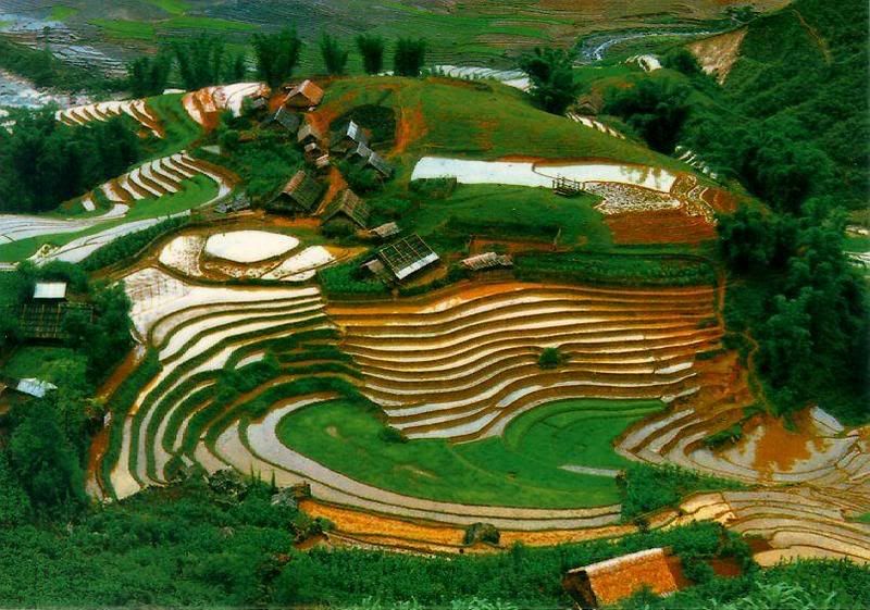
Tourism
Lao Cai preserves lots of special cultural and historical sites. Outstanding vestiges is ancient stone engrave area with picture of map, handwriting, people thousand years ago in Muong Hoa Valley (Sapa), Pho Rang vestige. There are many beautiful caves like Thuy Tien (Bat Xat), Ta Phoi (Cam Duong), Tien-Trung Do (Bac Ha), Xuan Quang (Bao Thang).
Lao Cai is very proud of Sapa, a unique natural tourist site. Many new married couples like spending their honeymoon in Sapa because of good weather and romantic sightseeing. Visitors to Sapa in summer can feel the climate of four seasons in one day. They enjoy discovering other interesting places including Ham Rong Mountain, Silver Waterfall, Rattan Bridge, Bamboo forest, Ta Phin Cave and Sapa ancient rock field. Taken place every Saturday night, Sapa Market is an attractive place for visitors who are keen on exploring traditional cultures.
In addition, Bac Ha Market hosts the biggest fair near the mountainous highlands. It is a typical weekly activity for the H'Mong and other minority groups living in the locality. In Cat Cat Village many H'Mong residents are good at manipulating gold and silver jewelry.
It is festinate to travel from Lai Chau to Lao Cai following National Highway No. 4D because of scenery along roadsides and impressive sight of Hoang Lien Son Range. This way attracts to people liking the adventure and discover on bicycle, too.
Ethnic groups
Lao Cai has a colorful culture of 27 ethnic groups. They are Kinh, H'Mong, Tay, Dao, Thai, Giay, Nung, Phu La, Ha Nhi, Lao, Khang, La Ha, Muong, Bo Y, Hoa, La Chi, San Chay, San Diu, Khmer, Lo Lo, Ka Doong, Pa Co, E De, Gie Trieng, Gia Rai, Cham, Ka Tu. The life of minority people groups base on planting rice on the paddy, on the fields in the mountains or on terraced field.
Festivals here are very special including Pray for good crop, Spring Mountain, and Long Tong festivals. There are many merry games such as nem con, tug-of-wars, cockfights.
Transportation
Located 300km from Hanoi, Lao Cai can be reached by car or train. There is National Highway No.70, 279, 4D linking Lao Cai to Yen Bai, Lai Chau and Ha Giang, China in turn. There are two trains depart from Hanoi daily to Lao Cai.
-->read more...

Lang Son travel

Geography
Lang Son is a frontier mountainous province in the North-East of Vietnam. It shares border with Cao Bang Province on the south, Bac Giang Province on the north, Guangxi (China) on the east, Quang Ninh Province on the north-east and Bac Kan, Thai Nguyen provinces on the west.
Mountains and hills cover over 80% of the province's total area. The complex network of rivers makes a good condition for agriculture. Main rivers that run through the province are: Ky Cung, Ba Thin, Bac Giang, Bac Khe, Thuong, Hoa, and Trung rivers.
Lang Son has two international border gates including Dong Dang railway border gate and Huu Nghi road border gate, two national border gates such as Chi Ma (in Loc Binh District) and Binh Nghi (in Trang Dinh District)... So Lang Son has an important strategic position in the North-East of Vietnam.
The climate is cool and temperate. Annual average temperature is 21.5�C. Annual average rainfall is from 1200mm to 1600mm.
Tourism and Economy
Lang Son has potentiality of mineral, forestry, tourism and trading. Star aniseed (hoa hoi) is a specialty. The province is proud of many culture and historical vestiges. They are Rampart of Mac Dynasty, Doan Citadel Vestige, Chi Lang Defile, Ky Cung and Bac Le temples. Apart of these, Ky Lua Market, To Thi and Mau Son mountains, Tam Thanh, and Nhi Thanh grottoes also attract many visitors every year. Especially, lots of people come to Ky Lua and Tam Thanh markets to shopping because the goods are abundant and cheap.
Coming to there, tourists are interesting in Ky Lua or Long Tong traditional festivals. They would like to taste special dishes: roast duck, roast pig, Mau Son wine and lam rice.
Transportation
Lang Son is 154km from Hanoi, 60km from Thai Nguyen, 48km from Quang Ninh, 55km from Cao Bang, 73km from Bac Kan.
Road: National highway routes on the territory of Lang Son province:- No.1A: It departs from Huu Nghi Quan (Friendship Gate) and runs through Lang Son Province to Hanoi.- No.1B: between Lang Son and Thai Nguyen.- No.4A: between Lang Son and Cao Bang.- No.4B: from Lang Son to Tien Yen Townlet of Quang Ninh Province.- No.31: between Dinh Lap and Bac Giang- No.279: Binh Gia of Lang Son Province to Bac Kan.
Train: Hanoi-China international railway line with over 100km runs through Lang Son.
-->read more...

Hung Yen travel

Geography
Located in center of Red River Delta, Hung Yen shares border with Bac Ninh Province on the north, Ha Nam Province on the south, Hai Duong, Thai Binh provinces on the east, Ha Tay Province and Hanoi on the west.
Terrain in Hung Yen is quite event and flat with many rivers. Hong, Luoc, Cuu An, Ke Sat rivers surrounds three sides of province. In addition of that, there are Kim Nguu, Nghia Ly, and Bac Hung Hai rivers.
Climate: Hung Yen belongs to monsoon - tropical climate area. There are clearly two seasons: the hot and the cold seasons. Cold season is dry, from November to April next year. In hot season, it rains a lot from May to October. The annual average temperature is about 23ºC.
Tourism
The famous site in Hung Yen is Pho Hien relic group, including Van Mieu, Hien, Chuong pagodas, Mau Temple. Other popular sites are Kim Chung, Huong Lang, Thai Lac, Ne Chau pagodas, Chu Dong Tu, Phuong Hoang, Dau An, Da Hoa temples.
Hung Yen is home of famous people like Nguyen Binh, Hoang Hoa Tham, Doan Thi Diem, Le Huu Trac, Chu Manh Trinh, Vu Trong Phung, Nguyen Cong Hoan, To Ngoc Van, Pham Huy Thong.
Coming to there, visitors enjoy traditional songs such as cheo, a dao, trong quan or take part in Chu Dong Tu, Tu Phap, An Xa Village, Ghenh Temple, Co Le, Tho Hoang hamlets festivals.
Especially, Hung Yen's cape-longan is very well-known. This sweet longan with a thick pulp and a thin peel, used to be offered to kings only.
Transportation
Hung Yen Town is 60km from Hanoi.
Hung Yen locates on National Highway No.5: Hanoi - Hung Yen - Hai Duong - Haiphong. There is National Highway No.39 linking from My Hao District to Hung Yen Town and then Thai Binh. National Highway No.38 connects to Bac Ninh.
Hanoi - Haiphong railway also comes over Hung Yen.
-->read more...

Hue Travel


Located on the country’s central coast in Thua Thien Hue province , the area has variety of sites of outstanding nature beauty. The average temperature is about 25 degrees. The area is also notorious for its torrential rain, which can pour unabated for a week. The beauty of the area led it to be chosen as the capital by the kings of the Nguyen dynasty. It was recently recognised as a Unesco world heritage site. Hue also features a unique cuisine, combining dishes associated with the former imperial court with everyday street food, much of fairly spicy. The city is also noted for the quality of its embroidery, particularly on the traditional ao dai-a favourite sovernir for visitors to take home.Thien Mu PagodaSeven km west of the city centre, this pagoda was built in the 14th century in honour of a red-robed goddess.Ancient CitadelThe fisrt king of the Nguyen Dynasty, Gia Long,began construction of the complex in 1805. The present citadel , including the Forbidden City, occupies an area of 5.2sq km on the north bank of the Perfume river.Around HueBach Ma National PackBach Ma , known as the Dalat of central Vietnam, is 50km south of Hue. The pack covers 220sq km and it home to many rare plants and animals. Pick up a guide at the visitors centre: entrance cost $2 and guide can be hired for $12 a day.Lang Co Beach70km south of the city. Go by taxi or get a bus from An Cuu bus stationCanh Duong Beach60km from Hue, this crescent shaped 8km is the most beautyful in the region. Its sand is white and soft and there is usually a mild breeze, making it a favourite spot for windsurfing and sailing
-->read more...

Hoi An travel

Unesco last year named the town as one of Vietnam’s four World Heritage sites. Hoi An is now part of Quang Nam province.
Japanese BridgeBuilt in 1593 by the town’s Japanese community. The bridge links Tran Phu and Nguyen Thi Minh Khai streets.
Phuoc Kien Assembly HallAt 46 Tran Phu, the place where merchants from Fujian province (Phuoc Kien in Vietnamses) in China used to gather.
Quan Cong TempleAt 24 Tran Phu in the north side of the Hoi An market , this temple is dedicated to Quan Cong, a Chinese general.
Cua Dai BeachGreat beach 5km of Hoi An town . Sit in a deckchair and dine on seafood.
Tra Kieu CitadelA 15th century Champa fortress in Duy Xuyen distric.
Chien Dan TowerBuilt in the 11th century in honour of the Champa’s Hindu deities . In Tan Ky town, 55km west of Hoi An.
Suoi Tien SpringsA noted beauty spot in Que Son distric, with 13 waterfalls nestled among mountains and forests.
My Son SanctuaryThe holy Champa city ,built in the fourth century , was recognised as a world heritage site in 1999. It was the sight of the important Cham intellectual and religious centre, and also served as a burial place for Cham monarchs. The monuments here are set in a verdant valley surrounded bu hills and shadowed by the massive Cat’s Tooth Mountain(Hon Quap). Clear brooks (perfect for a dip) run between the structures and past nearby coffee plantations. Most of the temple in My Son were dedicated to Cham kings associated with divinities.
-->read more...